
| glossary | menu | Normal | lg | hc | 9.) Fluvial Geomorphological Applications in River Forecasting > Tidal Influence - Sacramento River of CNRFC |
| < Previous | 1 | 2 | 3 | 4 | 5 | 6 | 7 | 8 | 9 | 10 | 11 | 12 | 13 | 14 | 15 | Next > |
Tidal Influence - Sacramento River of CNRFC

This live Internet image shows the region surrounding the Sacramento River of California near Yolo Bypass at Lisbon. Yolo Bypass at Lisbon is located just below the center of the displayed map. The CNRFC is responsible for operational forecasting in this region. Yolo Bypass at Lisbon is important for wildlife and recreational uses, yet the riparian and wetland vegetation management, such as sage, is challenging due to the oscillations in water level with coastal estuary influences. Gage observations are critical for this location.
Upstream of Yolo Bypass at Lisbon is another Yolo Bypass, and upstream of that is the Fremont Weir (just above center of image), which regulates flow into the Yolo Bypass. This regulation will be explored further in this FGM Module Section.
USGS reports state that the Bankfull stage for this section of river is at 14 ft. Flows at 14 ft are typically contained near the channel and not considered a flood threat. Flood stage is established at 20 ft. This flood stage is a lowered value than earlier levels, and used to better manage the competing uses in the Yolo River basin.
Please note, if the picture is absent, there may be a problem with the remote server, and you can click on this smaller image to see an archived picture of the site. 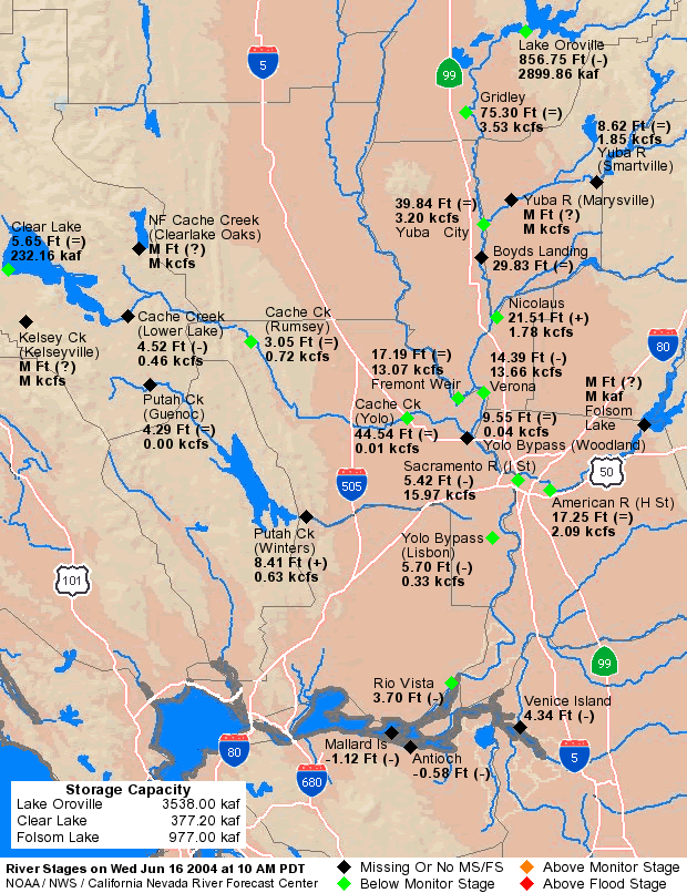 Image courtesy of NOAA
| < Previous | 1 | 2 | 3 | 4 | 5 | 6 | 7 | 8 | 9 | 10 | 11 | 12 | 13 | 14 | 15 | Next > |