
| glossary | menu | Normal | lg | hc | 9.) Fluvial Geomorphological Applications in River Forecasting > FGM Applications in RFCs |
| 1 | 2 | 3 | 4 | 5 | 6 | 7 | 8 | 9 | 10 | 11 | 12 | 13 | 14 | 15 | Next > |
FGM Applications in RFCs
This Fluvial Geomorphology Module Section will introduce River Forecast Center (RFC) operational applications. FGM Module Section 1 explained that this training series would introduce the field of fluvial geomorphology, and illustrate linkages between FGM and river forecasting.
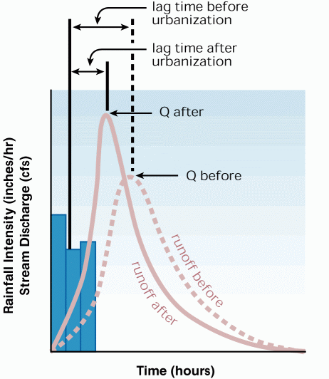
Daily applications of FGM theory to operational hydrology likely occur in the work of seasoned modelers and forecasters adjusting watershed and hydrodynamic model inputs and outputs for local conditions and features. As this image shows, river and Floodplain adjustments are often understood as causing shifts in hydrograph timing and magnitude. Unfortunately, much of this regional geomorphological knowledge has not been committed to training manuals. In development of the FGM Module all RFCs were contacted and asked to share operational insights on how FGM influences modeling and forecasting. Case studies are shared by two RFCs in this FGM Module Section.
River Forecast Centers of the National Weather Service are presently considering the ramifications on FGM features on operational flood routing and prediction. In most cases, there is not direct connection between these current RFC operations and Rosgen channel classification schemes presented as Levels I, II, and III. In time, however, this may change as RFC personnel become more familiar with the influence morphologic classification values such as entrenchment ratio, width to depth ratio, and Sinuosity have on flood behavior.
Completion of this FGM Module Section will provide exposure to RFC experiences with the challenge and opportunity presented by regional geomorphological features in flood forecasting and modeling. The karst topography of the Southeast RFC (SERFC) and the tidal influence of the California Nevada RFC (CNRFC) are presented. At the close, initial thoughts are shared on how RFC personnel might approach routing model adjustment based on Rosgen classification and general fluvial geomorphological analysis.
Image courtesy of FISRWG
| 1 | 2 | 3 | 4 | 5 | 6 | 7 | 8 | 9 | 10 | 11 | 12 | 13 | 14 | 15 | Next > |