
| glossary | menu | Normal | lg | hc | 7.) Classification and Channel Geometry Relations > Ouachita River Gauge Background |
| < Previous | 1 | 2 | 3 | 4 | 5 | 6 | 7 | 8 | 9 | 10 | 11 | 12 | 13 | 14 | 15 | 16 | 17 | 18 | 19 | 20 | 21 | 22 | 23 | 24 | 25 | 26 | 27 | Next > |
Ouachita River Gauge Background
Background data on the Ouachita River gage and channel come from a 12/13/2001 report by USGS employee J.S. Wallace. They are provided for your optional review.
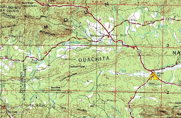
LOCATION: Lat 34 36 35.9 (DMS), Long 93 41 49.5 (DMS), in SE1/4SW1/4, sec.32, T.1 S., R.25 W., Montgomery County, Hydrologic Unit 08040101, on right bank, 350 ft upstream from bridge on U.S. Highway 270, 3.1 mi upstream from Fiddler's Creek, 5.2 mi northwest of Mount Ida, and at mile 553.4. Road log: From the junction of Ark.Hwy 27 and U.S. Hwy 270 just west of Mt. Ida, drive northwest on U.S. Hwy 270, 5.2 mi to Hwy 270 bridge over Ouachita River. Gage is about 350 ft upstream on right bank.
DRAINAGE AREA: 414 sq mi.
ESTABLISHMENT: Nov. 1, 1941, by U.S. Army Corps of Engineers.
GAGE: Sutron 8200-A DCP and Handar 436-A encoder installed in a 42" CMP shelter over 42" stilling well on right bank 350 ft upstream from bridge on U.S. Highway 270. Communication with the Stream is through two 2 1/2 inch intake pipes each being 44-ft long and equipped with three-way cock valves connected to a flushing system. Both U.S. Army Corps of Engineers, and Geological Survey gages were set to Datum of 655.14 ft above mean sea level.
CHANNEL AND CONTROL: Channel is straight for about 1,500 ft upstream and about 800 ft downstream and is composed of gravel and bedrock. Both banks of the Stream are wooded. The right bank at gage is a high bluff but will overflow 400 ft downstream.
Image courtesy of USGS
| < Previous | 1 | 2 | 3 | 4 | 5 | 6 | 7 | 8 | 9 | 10 | 11 | 12 | 13 | 14 | 15 | 16 | 17 | 18 | 19 | 20 | 21 | 22 | 23 | 24 | 25 | 26 | 27 | Next > |