
| glossary | menu | Normal | lg | hc | 6.) Rosgen Classification of Detailed Stream Type > Rosgen Morphological Description |
| 1 | 2 | 3 | 4 | 5 | 6 | 7 | 8 | 9 | 10 | 11 | 12 | 13 | 14 | 15 | 16 | 17 | 18 | 19 | 20 | 21 | 22 | 23 | 24 | 25 | 26 | 27 | 28 | 29 | 30 | 31 | 32 | 33 | 34 | 35 | 36 | 37 | 38 | 39 | 40 | 41 | 42 | 43 | 44 | 45 | 46 | 47 | 48 | 49 | 50 | 51 | 52 | 53 | 54 | 55 | 56 | 57 | 58 | 59 | 60 | 61 | 62 | 63 | 64 | 65 | 66 | 67 | 68 | 69 | Next > |
Rosgen Morphological Description
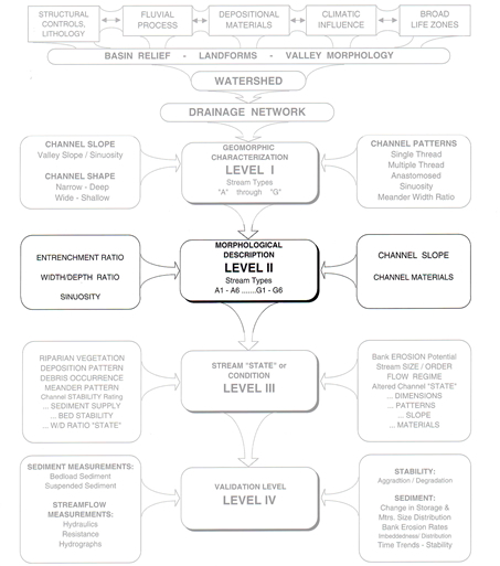
This Fluvial Geomorphology Module Section will introduce Rosgen Level 2 classification of river Reaches. This Level 2 morphological description is more field-based than the map-based Level I. While the Level I geomorphologic characterization focused on Valley type and channel pattern from plan form data, Level II intensifies the morphologic description.
Several Level II Reach types are identified in this FGM Module Section, occupying slides fg_6_5 to fg_6_51. Students may wish to skip over parts of this catalog of river types by browsing the FGM Module Menu. It is likely that the general aspects of river types in the same letter (e.g., A to G) will appear relatively constant for the beginning student while variation is kept to substrate (e.g., 1 to 6), and becomes predictable.
Level II data capture occurs in the field, and requires more extensive pattern and profile assessments along with detailed dimension measurements. Determination of Bankfull features in the cross-sectional analysis, discussed in an earlier section, is critical for success in Rosgen Classification. From this work, entrenchment ratio, width to depth ratio, slopes, Meander attributes, and channel materials are quantitatively described.
As indicated in the earlier module section, Level II classification utilizes geomorphological information on channel entrenchment ratio, width to depth ratio, Sinuosity, Channel Slope, and channel materials to more precisely categorize Stream types A to G and substrate types 1 to 6. Many of these measurements are relative to the Bankfull feature, which marks the transition between channel and Floodplain. It is common that the Bankfull feature is more easily detected on one side of the cross-section, often at the point bar, where the Floodplain is building.
Exercises at the end of this FGM Module Section will explore pattern, profile, dimension, and substrate analysis for a Reach of the Ouachita River in Pine Bluff, Arkansas. These exercises will demonstrate aspects of Rosgen Level II analysis by providing constructed data that otherwise would be acquired from an extensive field site survey. Completion of the exercises will ready you for subsequent Level II classification.
Image courtesy of Rosgen
| 1 | 2 | 3 | 4 | 5 | 6 | 7 | 8 | 9 | 10 | 11 | 12 | 13 | 14 | 15 | 16 | 17 | 18 | 19 | 20 | 21 | 22 | 23 | 24 | 25 | 26 | 27 | 28 | 29 | 30 | 31 | 32 | 33 | 34 | 35 | 36 | 37 | 38 | 39 | 40 | 41 | 42 | 43 | 44 | 45 | 46 | 47 | 48 | 49 | 50 | 51 | 52 | 53 | 54 | 55 | 56 | 57 | 58 | 59 | 60 | 61 | 62 | 63 | 64 | 65 | 66 | 67 | 68 | 69 | Next > |