
| glossary | menu | Normal | lg | hc | 5.) Rosgen Classification of Valley & General Stream Type > Rosgen Geomorphic Characterization |
| 1 | 2 | 3 | 4 | 5 | 6 | 7 | 8 | 9 | 10 | 11 | 12 | 13 | 14 | 15 | 16 | 17 | 18 | 19 | 20 | 21 | 22 | 23 | 24 | 25 | 26 | 27 | 28 | 29 | 30 | 31 | 32 | 33 | 34 | 35 | 36 | 37 | 38 | 39 | Next > |
Rosgen Geomorphic Characterization
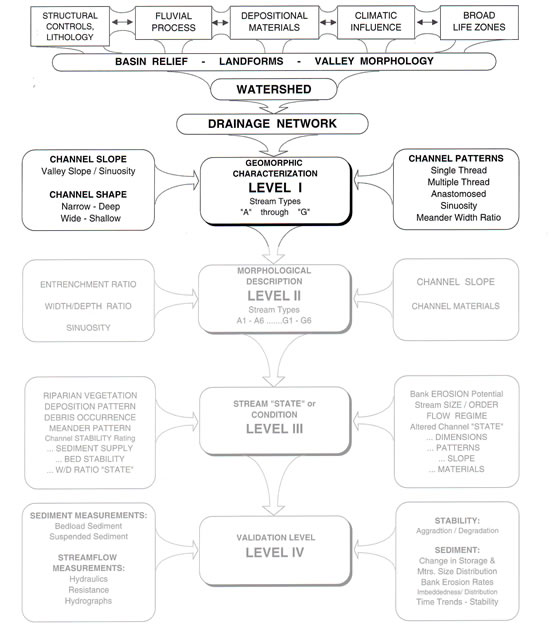
This Fluvial Geomorphology Module Section will introduce Rosgen Level 1 classification to Valleys and Reaches within a landscape. This Level 1 geomorphic characterization incorporates watershed assessment of Valley morphology in order to understand probable Stream types A to G. The geomorphic assessment is traditionally performed using aerial photographs and contour maps of the plan form. When measuring aerial photos for FGM features, caution should be exercised if the image has an oblique (off-nadir) view angle and creates significant foreshortening.
Level 1 classification attempts to understand FGM the pattern (plan form view), profile (longitudinal view), and dimension (cross-sectional view) of the fluvial landscape.from available remotely sensed imagery. In certain cases, adequate imagery may be lacking, and a geomorphic characterization may require field visits to gather necessary data. Level 1 involves an assessment of the general Valley type, channel pattern (e.g., single thread, multiple thread, sinuous, straight), Valley and channel profile (e.g., slope), and rough estimate of dimension (e.g., narrow and deep or wide and shallow).
Dimension analysis is the most difficult component of Level 1 classification given the relatively small size of the channel compared to the map scale and its portrayal of landscape detail. Fortunately, estimating channel width and depth for Level 1 work need only approximate relative ratios, such as Entrenchment Ratio greater or lesser than a value of 1.4 or 2.2, or width to depth ratio greater or lesser than a value of 12. Even with such broad categories, however, maps and photos may prove inadequate.
Level 1 analysis ties directly to higher level classification, which is pursured in later FGM Module Sections. After Level 1 Valley type and Stream type been initially determined, information about channel material could be assessed to add a numeric descriptor, 1 to 6. This detail of work is typically performed in Level II classification, where channel pebble surveys are used for understanding relative abundance. Again, recalling the continuum concept of FGM classification, field measurements of Bankfull ratios will provide numeric precision that enables a better characterization of Stream type.
Image courtesy of Rosgen
| 1 | 2 | 3 | 4 | 5 | 6 | 7 | 8 | 9 | 10 | 11 | 12 | 13 | 14 | 15 | 16 | 17 | 18 | 19 | 20 | 21 | 22 | 23 | 24 | 25 | 26 | 27 | 28 | 29 | 30 | 31 | 32 | 33 | 34 | 35 | 36 | 37 | 38 | 39 | Next > |