
| glossary | menu | Normal | lg | hc | 1.) Fluvial Geomorphology Training Module > Plan View - Pattern |
| < Previous | 1 | 2 | 3 | 4 | 5 | 6 | 7 | 8 | 9 | 10 | 11 | 12 | 13 | 14 | 15 | 16 | 17 | 18 | 19 | 20 | 21 | 22 | 23 | 24 | 25 | 26 | 27 | Next > |
Plan View - Pattern
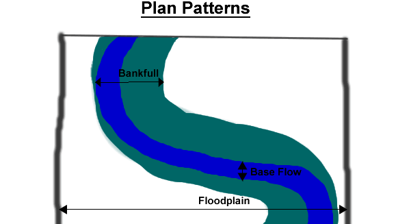
The plan view, or pattern, is an overhead observation presented for diagrams, maps, or images to show the patterns that are present. Here it illustrates components in a river system. Components of the plan view include Bankfull Width, base flow width, and flood plain extent, as well as many Meander features that are described in later FGM Module Sections.
| < Previous | 1 | 2 | 3 | 4 | 5 | 6 | 7 | 8 | 9 | 10 | 11 | 12 | 13 | 14 | 15 | 16 | 17 | 18 | 19 | 20 | 21 | 22 | 23 | 24 | 25 | 26 | 27 | Next > |